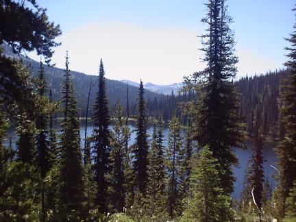
| Our second Bitteroot
outing of the season started on July 21 at Upper Twin Lake, at the end of the
Lost Horse Creek road, thirty miles southwest of Hamilton, at about
6500 feet elevation. Looking north across the lake, Lost Horse Pass
is just above the far shore. |

|
| Following the main trail along the
east shore, we soon can see our hiking goal for the day: Wahoo Pass,
directly west of the lake and nearly 1000 feet higher |

|
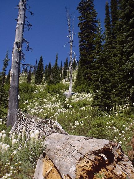
| We stopped at Lost Horse
Pass to admire the wildflowers in bloom. In addition to the yellow
alpine daisies, the evergreen ground cover was blooming. Higher up,
the hillsides were covered in bear grass, penstemon, and a riot of
other alpine flowers and flowering shrubs. |

|
| A pack train passed us at
Lost Horse Pass, headed up the Wahoo Pass trail. We soon followed,
enjoying the prolific stands of bear grass, whose pungent blossoms all
but covered up the "horse exhaust" fumes. |

|
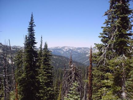
| Leaving Lost Horse Pass, the
Wahoo Pass trail climbs up the north face of the basin forming the
headwaters of Lost Horse Creek. |

|
| The trail climbs around the north
end of Upper Twin Lake, affording views of the Lost Horse Creek
drainage to the south. It was a nearly cloudless day, but mild after
a week of heavy thunderstorms and overnight temperatures dipping into
the 50s in the lower valleys. |
|
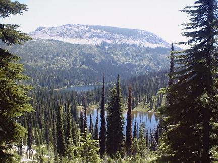
| A pleasant surprise awaits as tiny
Mud Lake, unnamed on some maps, comes into view as we climb through
7200 feet. Mud Lake sits in a hanging valley several hundred feet
above Upper Twin Lake. |

|
| The trail starts a long double
switchback to climb the face of the basin to Wahoo Pass. |
|
| Beyond Wahoo Pass, the trail skirts the
edge of a meadow at the base of the rocky Bitterroot divide that
separates Idaho and Montana, then begins a steep switchback trail
leading into Idaho's Selway-Bitterroot Wilderness to the west. |
|
| Turning back eastward, retracing our
steps gives excellent views of Mud Lake and Upper Twin Lake far
below. |
|
| As the trail traverses the north side
of the basin, an old, unmaintained trail leads to the outlet end of
Mud Lake. Rivulets of cold mountain water trickle from the steep
hillsides to feed the lake. All the shallow high mountain lakes sport
car-sized boulders pushed from the surrounding cliffs to the middle of
the lake by aeons of snow and ice. |

|
| A steep descent on the old trail
detours around erosion gullies and fallen trees to arrive back at
Upper Twin Lake near the outfall from Mud Lake. In mid-summer, the
water is still crystal-clear, and the seepage from the steep basin
sides floods the trail near the lake. The old trail follows the west
shore back to the parking lot and campground at the head of Lower Twin
Lake. A most pleasant Sunday mid-day outing. The hike took about
three hours of sight-seeing and wildflower-spotting. These jewel-like
mountain lakes in a basin filled with wildflowers and alpine varieties
of spruce, pine, and fir are well worth the 20 miles of one-lane
rock-strewn primitive road winding down the canyon. The road is
posted "not maintained for cars and trailers," and rightly so, with
steep grades, dips and humps over boulders, many blind turns, and
loose rocks the size of footballs in the road. |

|